Stansted
Stansted Mountfitchet has grown out of two main settlements, one along the Great Newmarket Road (B1383) once known as The Chapel, after the chapel that stood at the crossroads where the fountain is today; the other immediately to the east, at the bottom of Chapel Hill, and known as the Street (Lower Street), containing the oldest buildings including the remains of a Norman castle. Stansted Parish includes a further two hamlets, namely, Bentfield End in the west and Button (Burton) End in the east.
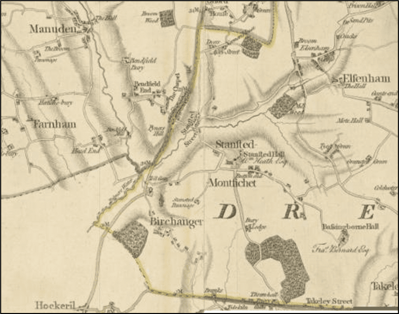
Stansted, or ‘stony place’ was held by Robert de Gernon at Domesday whose family name Mountfitchet was attached to that of the village to distinguish it from the other Stanstead. The Gernons’ park is recorded from the C12 when there were three manors in the parish – Burnells (Stansted Hall) and Thremhall Priory east of the B1383 and Bentfieldbury to the west. The C12 St. Mary’s church and the rebuilt C19 Stansted Hall and hillside park, lie between Lower Street and Burton End, while St. John’s church (built 1889) is centrally located on Chapel Hill. The River Stort flows from Elsenham into the bottom of Lower Street where it was first forded, then heads west to the B1383 and turns south to Stortford.
The first detailed map of the area was made in 1777 by Chapman and Andre and the components of the settlement. Following the coming of the railway in 1845, the population grew rapidly and the settlement is recorded on the 1875. The population trebled in the C19 and the settlement continued to grow significantly during the 20th century, continuing to take advantage of its proximity to good connexions. Bentfield End especially grew fast between 1896 and 1916.
Development since WWII has trebled the population again from 3,000 to an estimated 10,000 . Mountfitchet Estate – municipal housing built to the east of the railway – was swiftly mirrored by various estates west of the B1383 – Blythwood Gardens (1950s), Hargrave Estate, Cannons Mead and Wetherfield (1960s) and Bentfield Gardens (1970s). Smaller developments have been tucked into the eastern slopes at the centre of the village – St John’s Road and Burnells Way(1950s), Meadowcroft, Norman Court, Five Acres and Birchalls (1980s) and Spencer Close off Chapel Hill (1980s). The 1990s gave us Old Bell Close and Windmill Close off Silver Street and the intensification of habitation on Silver Street itself in the form of flats. The 2000s have contributed the Rochford nurseries (Forest Hall, some 700 dwellings), Elms Farm east of the Station and Walpole Meadows north of the village.
The site of the proposals has always been shown on the maps as fields south of Stansted Hall Park and St Mary’s Church as on the 1876 map shown below:
Birchanger
The village of Birchanger dates to the 5th Century and still retains the wooded slope which gives it its name. ‘Birch’ may indicate birch, or beech trees. The village centre is set on a high point for the locality which, with a good supply of timber, contributed to the creation of a settlement here. In the 9th century, Birchanger was under Danelaw and at Domesday, it was in Uttlesford Hundred and held by “Tascalin the priest … in almone of the King…… A community of about 30 is indicated paying tithes to the local manor. St Mary’s Church, the oldest building in the village is built of flint with dressings of limestone and clunch, between 1000 and 1200.
Traditionally Birchanger has been a farming community with large farms developing around large farmhouse. Two Mills processed grain which as transport links improved, found its way to the brewing and distilling industry that grew to feed the London market. By the late C19, farming could not support the whole village and brickworks in the Bradley Common area provided employment and support for new buildings. Throughout the 20th century though, sources of employment moved gradually further afield as local jobs declined.
The development site has been traditionally arable land north of Birchanger as shown on the 1777 map. The expansion of the village is noticeable on the 1972 OS map.